E-commerce Search Demo
AI Assisted Filters
Parameters
Query:
Category filters: All
AI Assist: ON
Page: 1
Products
Time taken: 3 Max score: 1000.000 Total hits: 100 Full time: 0.0 s
Showing 1-10 of 100 products
 B001B8N6CO Availability: Currently unavailable Score: 1000.000 Category: Electronics Rating: 3.5 Votes: 122 Find similar productsGarmin City Navigator North America for Detailed Maps of the United State, Canada and Mexico (DVD). Product Description With nearly 6 million points of interest and road coverage for the U.S., Canada and Puerto Rico, City Navigator North America NT gives you everything you need to travel North America. Powered by NAVTEQ, a world leader in premium-quality digital map data, City Navigator brings you the most detailed street maps available so you can navigate with exact, turn-by-turn directions to any address or intersection. Amazon.com Thanks to the Garmin MapSource City Navigator North America NT Version 8, which gives you access to all the data you need to navigate North America, you may never have to ask for directions again. This software automatically creates point-to-point routes in MapSource and on your NT compatible Global Positioning System (GPS), and includes detailed, premium street maps of North America, plus a hefty points of interest database at your fingertips. Featuring full coverage of the United States, Canada, and Puerto Rico, including metropolitan and rural areas, the Garmin MapSource City Navigator North America NT Version 8 makes it a snap to travel to a new city, look up your hotel, restaurants, and other services, and then use your compatible Garmin GPS to guide you there. For added convenience, you'll be able to take advantage of detailed maps containing highways, interstates, business and residential roads with attributes such as turn restrictions, roundabout guidance, speed categories and other navigation features. Ideal for vacation-planning, the Garmin MapSource City Navigator North America NT Version 8 also displays nearly six million points of interest, such as postal offices, attractions, shopping, and emergency services. The Garmin MapSource City Navigator North America NT Version 8 and data cards include the same detailed maps, points of interest and coverage areas as the traditional City Navigator North America data, just compressed differently for your NT compatible unit. The Garmin MapSource City Navigator North America NT Version 8 is designed for use with StreetPilot 2720, 2730, 2820, 7200, 7500 and the StreetPilot C-Series. It's also compatible with the StreetPilot i-Series, iQue 3000, M3, M4, Quest 2 and various handhelds such as GPSMAP 60Cx/60CSx/76Cx/76CSx and eTrex Legend Cx/Vista Cx. |  B002FIMRPG Availability: Currently unavailable Score: 7.194 Category: Electronics Rating: 4 Votes: 8 Find similar productsGarmin TOPO! 2009 North Central U.S. Map DVD (Windows or Mac). Outdoor enthusiasts: your adventure is waiting - in vivid detail. TOPO U.S. 24K North Central (DVD brings you the highest level of topographic detail available, with maps comparable to 1:24,000 scale USGS maps. These highly detailed maps on (DVD include terrain contours, topo elevations, summits, routable roads and trails, parks, coastlines, rivers, lakes and geographical points - and they also display 3-D terrain shading on compatible devices. With routable roads and trails in metropolitan and rural areas, getting to your destination is easy by creating point-to-point routes on compatible units. With this purchase, you'll receive topographic detail for Idaho, Montana, Wyoming, North Dakota, South Dakota, Minnesota, Nebraska and Iowa. You'll also receive BaseCamp software for managing data on your GPS and computer, playing back routes and tracks, geotagging photos and more. |
 B001OI2ZA0 Availability: Currently unavailable Score: 7.092 Category: Electronics Rating: 1 Votes: 1 Find similar productsGarmin GB Discoverer 2010 Pennine Way Topographical Map microSD Card. Explore Great Britain's national parks and trails with detailed topographic and road maps. Garmin GB Discoverer National Parks & Trails contains topographic maps from Ordnance Survey of Great Britain including OS Explorer Map as detailed as 1:25,000 scale and 1:50,000 scale Landranger maps for one region of the country. With NAVTEQ road data and points of interest for all of Great Britain, you'll get turn-by-turn directions to your destination. GB Discoverer's detailed topographic data includes terrain contours, topo elevations, summits, paths, routable roads and geographical points. The premium NAVTEQ road data is the same detailed data included in our leading automotive products — with thousands of addresses and points of interest, including lodging, food and drink, car parks, banks, petrol stations, attractions, campsites, and more. Search for an address or point of interest, and your Garmin device displays turn-by-turn directions to your destination. |  B002URQ3HU Availability: Currently unavailable Score: 6.667 Category: Electronics Rating: 3 Votes: 3 Find similar productsDelorme Street Atlas USA 2010 Map Software. Ideal for Laptops, Netbooks, Phones and GPSProduct InformationStreet Atlas USA 2010 DVD puts you in complete control, unlike online mapping sites and other mapping software. Plan perfect trips by generating automatic routes, selecting precisely the roads you want to take along the way. See time and mileage differences selecting among alternate routes. Add your own new local roads to planned developments and include in your routes and directions. Select from four million places of interest (no Web connection needed). Plan the perfect trip every time and navigate worry-free with Street Atlas USA 2010.Product HighlightsDetailed highway and street detail for the U.S. and Canada, highway detail for Mexico.Always have the map you need as you travel. NoWi-Fi? No phone service? No problem! View high-resolution aerial imageryUse draw tools to add customized detailPre-plan your trips with automatic routing and access to over 4 million places of interest User controls let you plan side trips, avoid congested areas, choose back roads, more Locate restaurants, lodgings, attractions, truck stops, and businesses of all kindsCalculate your fuel usage and costsPrint a variety of map package, including turn details, auto-club-style strip maps, and more.MapShare - send maps, routes, directions, and notes to others via a secure Web linkGPS Ready! Connect a DeLorme Earthmate or other GPS to your laptop and: Hear spoken directions, issue voice commands, get large on-screen directionsTrack your travels in NavMode, with large, easily accessible user controls and optional 3-D perspectiveUse intelligent new E-Z Nav wizard to streamline your routing while on the goNew FeaturesE-Z Nav Route WizardIt makes on-the-go searching and GPS routing quicker and significantly streamlines the process. Users choose from among common travel categories and drill down to select the location they want from an easy-to-read icon-b. |
 B00P0DM26M Availability: Currently unavailable Score: 6.250 Category: Electronics Rating: 5 Votes: 1 Find similar productsGarmin Us Lakevu Hd Microsd/Sd Charts For Gpsmap, Oregon, And Product Category: Cartography - Garmin/Inland Lakes. GARMIN US LAKEVU HD MICROSD/SD CHARTS FOR GPSMAP, OREGON, AND - LakeVü™ HD - microSD™/SD™ - With maps of more than 17,000 U.S. lakes - many with 1' contours throughout - this HD-mapping product brings new levels of detail to your chartplotter. - Features - Contains more than 400 HD lakes with 1' contours throughout to help you pinpoint the best places to find fish - Displays points of interests, including docks, designated fishing areas, campgrounds, boat ramps, marinas and bridges - Shows interstates, highways and general roads - Shows underwater features, such as riverbeds, bridges, roads, fish attractors and potential hazards - Offers Safety Shading, which lets you input and shade a minimum depth to help you avoid running aground Coverage: - Features detailed coverage of more than 17,000 freshwater lakes, resevoirs and rivers throughout the continental U.S. - Compatible Devices - GPSMAP® Series - Montana® 6xx Series - Oregon® 6xx Series -. | 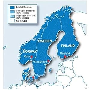 B00XIQKXQE Price: $72.75 Score: 6.211 Category: Electronics Rating: 4 Votes: 82 Find similar productsGarmin City Navigator Nordics for Detailed Maps of Denmark, Finland, Norway, and Sweden (microSD/SD Card). Everything you need to travel the Nordic countries is included in these highly detailed street maps. Load City Navigator Europe NT Nordics directly to your device and navigate turn by turn to any address or intersection. Route to points of interest including restaurants, petrol stations, lodging, attractions and more. Coverage includes detailed maps of Denmark, Finland, Iceland, Norway and Sweden. Powered by NAVTEQ, a world leader in premium-quality digital map data. |
 B00FMUYYZA Availability: Currently unavailable Score: 6.135 Category: Electronics Rating: 3.8 Votes: 249 Find similar productsGarmin nüvi 2798LMT Portable GPS with Backup Camera. Advanced Series Navigation with Backup Camera 7.0 display 7.0 display Comes with BC™ 20 wireless backup camera Comes with BC™ 20 wireless backup camera Detailed maps of North America with free lifetime map¹ and traffic² updates Detailed maps of North America with free lifetime map¹ and traffic² updates Garmin Real Directions™ with Garmin Real Voice™ Garmin Real Directions™ with Garmin Real Voice™ Voice-activated navigation, Bluetooth® and Smartphone Link compatible Voice-activated navigation, Bluetooth® and Smartphone Link compatible Detailed Maps with Free Updates nüvi 2798LMT arrives with a bright 7.0 display and loaded with detailed maps of North America. With free lifetime¹ map updates, your routes are sure to reflect the most up-to-date maps available, points of interest (POIs) and navigation information. New maps are available for download with no fees. With so much data, nüvi 2798LMT makes it easy to find addresses and millions of POIs such as businesses, stores, restaurants and other destinations. nüvi 2798LMT arrives preloaded with POIs, so there’s no need for you to enter that address information. Just select one — or many — and navigate there, quickly and easily. You also have the ability to add custom POIs to your nüvi 2798LMT. Wireless Backup Camera Included nüvi 2798LMT comes bundled with the BC 20 wireless backup camera. Easily spot vehicles, pedestrians and other obstructions right on your screen as you back up your vehicle. The transmitter will send camera footage to nüvi 2798LMT from up to 45 ft (13.7 m) away. Professional installation recommended. Garmin Traffic nüvi 2798LMT features Garmin Traffic to help you spend more time on the move. With Garmin Traffic, your driving map remains onscreen at all times. Traffic alerts appear to the side of your map and messages are spoken, too. Garmin Traffic can give details about the situation, such as how many minutes of delay to expect and if there are any possible detours. It can even confirm whether or not you are on the fastest route. Garmin Traffic is voice activated, so it responds to spoken requests. Lifetime traffic² entitles your nüvi 2798LMT to receive free traffic information for its entire useful life. The Power of Your Voice nüvi 2798LMT has the luxury of voice-activated navigation. Speak, and your device intelligently responds; your hands can remain safely on the wheel. Of course, you can also navigate using the touchscreen interface. Make Hands-free Calls Sync a Bluetooth-enabled device, such as your smartphone, to nüvi 2798LMT for hands-free calling through its integrated microphone and speaker. Stow your phone in a glove compartment, pocket or purse and still make and take calls without moving your hands from the steering wheel or your eyes from the road. Smartphone Link Compatible Smartphone Link³ is a free mobile app that connects your nüvi 2798LMT with your iPhone® or Android™ smartphone. When paired, your nüvi 2798LMT can use your phone’s existing data plan to share information — such as where you parked, POIs and your destination. Smartphone Link also gives you access to Garmin Live Services⁴, useful real-time information such as weather and traffic conditions. Garmin Live Services are available free and by subscription. Garmin Real Directions with Garmin Real Voice nüvi 2798LMT redefines “spoken turn-by-turn directions” with Garmin Real Directions, easy-to-understand driving directions that guide like a friend, using recognizable landmarks, buildings and traffic lights. No more stress from trying to read street names. Garmin Real Voice is refined speech technology that sounds more like a natural, friendly voice. Garmin Real Directions and Garmin Real Voice are features that are only available in our line of GPS navigators. Comprehensive Driving Guidance You See and Hear Active Lane Guidance with voice prompts prepares you to drive through an exit or interchange with confidence. As you approach, an animated model uses brightly colored arrows to indicate the proper lane needed for your route; a friendly voice offers additional help. Bird’s Eye junction view offers a detailed view of interchanges, looking down as if from overhead. photoReal junction view realistically displays junctions and interchanges along your route, including the surrounding landscape. Brightly colored arrows indicate the proper lane to drive. nüvi 2798LMT also depicts real road signs as they appear along your route. More Information at a Glance nüvi 2798LMT keeps your driving map onscreen at all times and additional information appears alongside. For details, simply ask or touch the screen. As you drive your route, Up Ahead constantly informs you of nearby services, including restaurants, fuel stations, hospitals and stores. nüvi 2798LMT displays speed limit, current speed and accurate time of arrival. With a quick glance, you can read the name of your current street. nüvi 2798LMT also shows school zone warnings. One-stop Device Management Use Garmin Express to keep your nüvi up-to-date. Garmin Express makes it easy to update maps and software, transfer favorites to and from devices, and install free custom vehicles and voices. ¹Lifetime Maps Terms & Conditions can be found at http://www.garmin.com/en-US/legal/lmdisclaimer ²Lifetime Traffic Terms & Conditions can be found at http://www.garmin.com/en-US/legal/ltdisclaimer ³User’s data plan charges, if any, will apply. Contact your mobile service provider for more information about your service plan’s data and roaming rates. ⁴Subscription may be required. Android is a trademark of Google Inc. iPhone and App Store are trademarks of Apple Inc. |  B00TAEBVCI Price: $245.99 Score: 6.098 Category: Electronics Rating: 4.5 Votes: 2551 Find similar productsGarmin Nuvi 2595LMT. Garmin Nuvi 2595LMT Navigator The powerful Garmin Nuvi 2595LMT Navigator features Garmin Guidance 2.0, an advanced navigation engine that is fast, intuitive, and enhances the speed and accuracy of searches and routing for everyday driving. The Nuvi 2595LMT debuts a new advanced traffic avoidance system called Garmin 3D Traffic. Street navigation is made simple with voice prompted turn-by-turn directions, lane assist, and picture-quality Garmin photoReal junction view. The 2595LMT has a bright 5 display and includes subscription-free map updates for the life of your Nuvi, ensuring you have the most up-to-date mapping, points of interest, and navigation information. The following features are included in Garmin Guidance 2.0: Fast routing and map displays Fast, more intuitive destination searches (POIs) Garmin 3D Traffic subscription-free, extensive, live traffic service that combines trafficTrends, current traffic, and predictive traffic to provide re-route options, identify impending traffic backups, incidents, and even traffic cameras Lane assist with Garmin photoReal junction view guides you to the correct lane for an approaching turn or exit and displays digitized, high-quality photos (more than 58 thousand images) of the actual upcoming junction in incredible detail and even down to trees and pylons Voice-activated navigation speak complete addresses, points of interest and more to your Nuvi keeping your eyes on the road Exit services know what you'll find when you exit the highway See and select businesses on map (no need to page through menus) Garmin Locate automatically marks your position when you remove it from the windshield mount, so you can navigate with Nuvi on foot and find your way back to your vehicle Automatic volume control automatically adjusts volume for spoken directions and hands-free calling Speed limit indicator unit displays speed limits for most major roads Additional features: Easy-to-use, attractive 5 touch-screen display that manually. |
 B001U0O7RQ Availability: Currently unavailable Score: 6.098 Category: Electronics Rating: 3.9 Votes: 423 Find similar productsGarmin nüvi 1370/1370T 4.3-Inch Bluetooth Portable GPS Navigator (Discontinued by Manufacturer). Product description The NUVI1370T 4.3 Ultra Thin GPS Navigator features a widescreen ultra slim design (approximately 25% thinner than previous models), enhanced user interface, ecoRoute, public transit mode and text-to-speech. The n vi 1370T offers pedestrian navigation capability enabled through optional CityXplorer maps. CityXplorer maps are available for select tourist destinations in North America and Europe and can easily be downloaded directly to the nuvi. The nuvi's enhanced user interface features improved graphics and a new slide control for menu operation, while ecoRoute suggests fuel-efficient routes to save drivers money and fuel. Also, Garmin's new public transit mode allows you to navigate using buses, tramway, metro and suburban rail systems. Steer clear of traffic with nuvi's traffic receiver by receiving alerts about traffic delays and road construction that lie ahead on your route. Map data is provided by NAVTEQ Bluetooth wireless technology, enables hands-free calling with a compatible phone ecoRoute - Drivers can view suggestions for fuel-efficient navigation, conserving both money and fuel Speed limit indicator - unit displays speed limits for most major roads Public transit - Navigate using buses, tramway, metro and suburban rail systems with optional CityXplorer content. Download at garmin website Where Am I? feature - Find closest hospitals, police stations, gas stations, nearest address, intersection and coordinates Bright 4.3 diagonal color display; 480 x 272 pixels; WQVGA TFT display with white backlight Trip computer records mileage, max speed, total time Built-in travel kit includes picture viewer, world clock, currency and measurement converters and calculator MicroSD memory card slot Offers 3-D mapping, or 2-D overhead view Dimensions - 4.8W x 2.9H x 0.6D; Weight - 5.7 ounces Built-in lithium-ion battery - Lasts up to four hours depending on usage Includes suction cup Amazon.com Get more maps and less profile with the widescreen nüvi 1370T. This thin navigator has preloaded maps for North America and Europe, lane assist, pedestrian navigation options, hands-free calling, subscription-free traffic alerts and ecoRoute™ to calculate a more fuel-efficient route. An ultra-thin GPS navigator with great Garmin features like CityXplorer and ecoRoute. Click to enlarge. Receive Subscription-Free Traffic Alerts Get more maps and less profile with the widescreen nüvi 1370T. This thin Travel the world with the 1370T, featuring full coverage maps for North America and Europe. Click to enlarge . Garmin greets you with two simple questions: Where to? and View Map. This screen is central to every navigation function and route-planning tool. Simply plug and play. Click to enlarge. The device announces the name of exits and streets so you never have to take your eyes off the road. Click to enlarge. Lane assist guides you to the correct lane for an approaching turn or exit, making unfamiliar intersections and exits easy to navigate. Click to enlarge. navigator has preloaded maps for North America and Europe, lane assist, pedestrian navigation options, hands-free calling, subscription-free traffic alerts and ecoRoute™ to calculate a more fuel-efficient route. Receive Free Traffic Alerts Steer clear of traffic with nüvi 1370T's integrated FM traffic receiver and free lifetime¹ traffic updates. Receive alerts about traffic delays and road construction that lie ahead on your route. Next, simply touch nüvi's screen to view traffic details or detour around the problem area. Know the Lane Before It’s Too Late No more guessing which lane you need to be in to make an upcoming turn. Lane assist guides you to the correct lane for an approaching turn or exit, making unfamiliar intersections and exits easy to navigate. Navigate City Transit With its enhanced pedestrian navigation capabilities, nüvi 1370T is the perfect travel companion for getting around town. Download optional cityXplorer™ content to help you navigate city public transit. Know where to walk, where to catch the bus, subway, tram or other transportation and how long it will take to get there. nüvi 1370T easily fits in your pocket or purse. cityXplorer maps are available for select cities throughout North America and Europe. And with prices as low as $9.99, you'll have money left over to spend in the big city. See More With nüvi 1370T's widescreen display, you'll always get the big picture. View map detail, driving directions, photos and more in bright, brilliant color. Its sunlight-readable, 4.3 (10.92 cm) display is easy to read, from any direction. Get Turn-by-Turn Directions nüvi 1370T's intuitive interface greets you with two simple questions: Where To? and View Map. Touch the color screen to easily look up addresses and services and get voice-prompted, turn-by-turn directions that speak street names to your destination. It comes preloaded with detailed City Navigator® NT street maps for both North America and Europe, millions of points of interest (POIs), 2-D or 3-D maps and the speed limit for most major roads in the U.S. and Europe. Its digital elevation maps show you shaded contours at higher zoom levels, giving you a big picture of the surrounding terrain. With the 1370T's enhanced user interface, you can slide your finger to conveniently scroll between screens. You also can upload custom points of interest (POIs). And with HotFix® satellite prediction, nüvi calculates your position faster to get you there quicker. Make Hands-free Calls For hands-free calling, nüvi 1370T integrates Bluetooth® wireless technology with a built-in microphone and speaker. Just pair it with your compatible Bluetooth phone and talk hands-free through the 1370T while staying focused on the road. Simply dial numbers with nüvi's touchscreen keypad to make a call. To answer calls, just tap the screen and speak into its built-in microphone. Enjoy convenient one-touch dialing for contacts and points of interest. Go Beyond Navigation Navigation is just the beginning. nüvi 1370T saves you gas and money with ecoRoute — a green feature that calculates the most fuel-efficient route, tracks fuel usage and more. The 1370T includes many travel tools, including JPEG picture viewer, world travel clock with time zones, currency converter, measurement converter, calculator and more. With photo navigation, you can download pictures from Garmin Connect™ Photos and navigate to them. With its Where Am I? emergency locator, you always know your location. Simply tap the screen to get your exact latitude and longitude coordinates, the nearest address and intersection, and the closest hospitals, police stations and fuel stations. The 1370T features Garmin Lock™, an anti-theft feature, and is compatible with our free Garmin Garage™ where you can download custom voices and vehicles. Enhance your travel experience with optional plug-in microSD™ cards. What's in the Box nüvi 1370, Preloaded City Navigator® NT North America (U.S and Canada) and Europe, Lifetime traffic¹, Vehicle suction cup mount, FM traffic receiver with vehicle power cable (indicated by T after model number on the box), Vehicle suction cup mount, USB cable, and Quick start manual Compare all Garmin nüvis Click the button below to compare by series, user type, and features. Visit Garmin.com at https://www8.garmin.com/support/download.jsp to get the latest firmware updates for your nüvi to keep it current and performing at its best. ¹Lifetime traffic extends for the useful life of your Garmin traffic receiver (as long as you own a compatible Garmin GPS) or as long as Garmin receives traffic data from its traffic supplier, whichever is shorter. Traffic content not available for all areas. See www.navteq.com/rdstraffic for traffic coverage areas and www.garmin.com/traffic/fm/navteq.html for program License Agreement containing complete terms and conditions. |  B001H9NR2Q Availability: Currently unavailable Score: 5.917 Category: Electronics Rating: 4.1 Votes: 311 Find similar productsTomTom ONE 125 3.5-Inch Portable GPS Navigator. Product Description TomTom ONE125¿s distinctive design puts a full-size touchscreen and the power of GPS in a slim, lightweight device. Switch on and go right out of the box. The crystal-clear display, 3D graphics and turn-by-turn spoken instructions help you find your way to any address in the United States ¿ all with just a few taps of the screen. Foldable EasyPort mount makes it easy to take it with you from car to car. TomTom has the most accurate maps and with TomTom Map Share technology you can instantly modify street names, street direction, and POIs on your own device. And now, there are added safety features so you can easily access local emergency providers. No activation, no monthly fees. From the Manufacturer TomTOm ONE 125 Maufacturer's Description--October 12, 2008 Just like the ONE 130, the TomTom ONE 125 has a nifty fold-out mount right into the device. No more trying to figure out where to stash that big, clunky mount in your car -- just pop it off, fold it up and carry the whole thing in your pocket. Of course, the ONE 125 also features the plug and play ease of use, rock-solid navigation, and sleek designs we've come to expect from TomTom. Key Features and Benefits Easy to Use right out of the box (Learn more) Easy to Use right out of the box ( Learn more ) Clear Directions from the sensitive touchscreen display with turn by turn spoken directions Clear Directions from the sensitive touchscreen display with turn by turn spoken directions Latest Map Guarantee means if a new map is released within 30 days of purchase, you can download it for free from TomTom HOME (Learn more) Latest Map Guarantee means if a new map is released within 30 days of purchase, you can download it for free from TomTom HOME ( Learn more ) TomTom Map Share lets you instantly modify street names, street direction and POIs on your own device and benefit from others' corrections (Learn more) TomTom Map Share lets you instantly modify street names, street direction and POIs on your own device and benefit from others' corrections ( Learn more ) Help Me! Emergency Menu gives one-touch access to local emergency providers such as police, fire stations and hospitals Help Me! Emergency Menu gives one-touch access to local emergency providers such as police, fire stations and hospitals Preloaded Complete Maps of the US with TeleAtlas data Preloaded Complete Maps of the US with TeleAtlas data EasyPort mount is foldable and slim for easy portability EasyPort mount is foldable and slim for easy portability POI icons easily find gas stations, restaurants, hotels and more along your route. Customize by adding your own points of interest POI icons easily find gas stations, restaurants, hotels and more along your route. Customize by adding your own points of interest TomTom HOME free software is a landing page for your TomTom on your computer that ensures that your TomTom is always up-to-date and access additional features TomTom HOME free software is a landing page for your TomTom on your computer that ensures that your TomTom is always up-to-date and access additional features QuickGPSfix speeds up the time it takes to fix your GPS position to help you drive off more quickly. QuickGPSfix speeds up the time it takes to fix your GPS position to help you drive off more quickly. Traffic-Capable with optional RDS-TMC traffic receiver accessory keeps you up-to-date on traffic events to minimize potential delays Traffic-Capable with optional RDS-TMC traffic receiver accessory keeps you up-to-date on traffic events to minimize potential delays Daily Fuel Prices, available as an optional service, finds the lowest priced gas on your route Daily Fuel Prices, available as an optional service, finds the lowest priced gas on your route Learn More Easy To Use Clear and easy screen interface Instant route re-calculation if you deviate from the planned route. Buy a TomTom device and it works straight out of the box: Just plug it in and a few taps of the touchscreen later, you're on your way with clear, turn by turn spoken directions complementing. TomTom's easy-to-use interface has been extensively tested by by independent assessors in the field and at TomTom’s unique User Experience Labs Preloaded Maps Comes preinstalled with complete maps of the United States Help When You Need It Extensive safety features including ‘Help Me’ menu for, to give drivers direct access to emergency services and roadside assistance. Icon-driven menu system Emergency menu gives you fast direct access to emergency numbers and direction to the nearest assistance New -- Small Mount, Big Speaker . The integrated EasyPort Mount means you never have to figure out where to stow a mount in your car, and you never leave a sign for potential thieves that there might be a tempting electronic prize under your seat. The entire unit, mount and all, is small enough to fit into a shirt pocket, so just fold it up and go! It comes with mounting discs for both windshield and dashboard. A large speaker gives you the best audio quality, eliminating distortions so you hear your instructions loud & clear. TomTom MapShare -- Maps Served Fresh Daily With TomTom Map Share you can update your map directly on your device as and when you spot road changes, and download daily updates from millions of Map Share users worldwide via your computer. Enabling Map Share gives you: instantly improved maps every day on your TomTom device instantly improved maps every day on your TomTom device entry into the world’s largest navigation community entry into the world’s largest navigation community the ability to share improvements daily with other TomTom users the ability to share improvements daily with other TomTom users full control over improvements that are uploaded and downloaded full control over improvements that are uploaded and downloaded the best and most accurate maps available – always. the best and most accurate maps available – always. Map Share changes you can make instantly: Block / unblock street Block / unblock street Reverse traffic direction Reverse traffic direction Edit street name Edit street name Add missing Points of Interest Add missing Points of Interest Edit Points of Interest. Edit Points of Interest. Report other error Report other error When joining the Map Share community you can select various 'levels of trust'. You might decide to only receive improvements that have been verified by TomTom or changes that have been submitted by tructed sources, by many , or by some people. Map Guarantee Due to Amazon's high volume of sales and frequency of inventory turnover, just about every portable GPS navigator sold by Amazon.com will come with the most recent map version. TomTom however, goes one better. Because TomTom regularly releases new maps, there's always a small chance that a newer map has been released since the production of your TomTom. With TomTom’s latest map guarantee, if the map preloaded on your device is not the latest version, you can download it FREE at TomTom HOME. This no longer requires the map check code . Checking in TomTom HOME is easy: Make sure you have the latest version of TomTom HOME installed on your computer Make sure you have the latest version of TomTom HOME installed on your computer Connect your device to your computer Connect your device to your computer In the 'File' menu click 'Use Latest Map Guarantee'. NOTE: if this option is not shown your device has the latest map. In the 'File' menu click 'Use Latest Map Guarantee'. NOTE: if this option is not shown your device has the latest map. You can check as many times as you like within 30 days from the date you first use your TomTom device. New -- Send Addresses Directly from Google Maps or Mapquest Search for the location you want. Pick Send to GPS. Itching to try out a new restaurant, or setting off on a road trip to locate the best donuts on the west coast? Now, it's easy to search for locations on Google Maps or Mapquest, then transfer the addresses directly to your TomTom. Install TomTom HOME on your computer Install TomTom HOME on your computer Hook up your TomTom to the computer via its USB port Hook up your TomTom to the computer via its USB port Search for the location you want. Click the Search for the location you want. Click the Click the Send link in the info window for the address. That will bring up a popup Send to form. Click the Send link in the info window for the address. That will bring up a popup Send to form. Pick GPS, then pick TomTom and hit the Send button. Pick GPS, then pick TomTom and hit the Send button. The address will instantly transfer to your TomTom device, The point will be saved as one of your favorites, and you can navigate to it or view it on a map just like with any other favorite. TomTom HOME HOME is TomTom's free software program that gives you access to a huge array of services as well as the global community of TomTom users. It is the only tool you need to manage, update and personalize your TomTom to enjoy a premium navigation experience: buy and install maps, make back-ups, download free software updates, shop and much more. Stay up-to-date – always get the latest TomTom software and updates. Stay up-to-date – always get the latest TomTom software and updates. Personalize – Add new points of Interest, routes, voices, colour schemes and more. Personalize – Add new points of Interest, routes, voices, colour schemes and more. Enhance – buy maps, subscribe to traffic and safety camera information services (optional). Enhance – buy maps, subscribe to traffic and safety camera information services (optional). QuickGPSfix Starting up can seem like a slow business, particularly if you’re in a hurry, because the GPS receiver needs to know exactly where each GPS satellite is to calculate your location. But satellites only broadcast their positions once every 30 seconds. So if any of their signals are interrupted, for example by passing high buildings, the whole position-fixing process has to repeat itself again and again until the perfect fix is achieved. QuickGPSfix takes a smarter approach. QuickGPSfix can speed up the time it takes to fix your GPS position by downloading the latest satellite data via an Internet connection. Just connect your TomTom device to your computer and TomTom HOME automatically downloads ‘QuickGPSfix’ – a special GPS data file that helps your TomTom fix your position quicker, even when the GPS signal is weak or partially blocked. This unique free service helps you fix your position and get navigating faster than ever. On the road or no access to TomTom HOME? Get the same ‘QuickGPSfix’ data by simply connecting to any TomTom PLUS service, using a wireless data connection. As soon as a connection is established, the ‘QuickGPSfix’ data is automatically updated. Note: QuickGPSfix data has limited validity. So to keep on getting a faster position-fix, re-connect your device at least once a week. To minimise the amount of data sent over your wireless data connection, this automatic update is only carried out if the data on your device is over 5 days old. The associated data usage of this service is less than 10 Kb per connection. Please contact your mobile service provider to determine the exact costs. To disable this automatic update, just select ‘Disable Auto QuickGPSfix’ on your TomTom device. Fun Extras to Personalize Your TomTom New smart & fun extras to personalize users’ devices Recording driving instructions in your own voice Recording driving instructions in your own voice Buy fun voices from TomTom Buy fun voices from TomTom Select a favorite car icon on the screen Select a favorite car icon on the screen Load, store and preview photos from your digital camera. Load, store and preview photos from your digital camera. Enjoy music with the built-in MP3 player (earphones connector available via an optional SD card) Enjoy music with the built-in MP3 player (earphones connector available via an optional SD card) TomTom Traffic With an RDS-TMC Traffic Receiver accessory, you can get traffic information from the RDS-TMC Traffic service, which is delivered over unused FM radio channels. Traffic information is fully integrated into the TomTom navigation experience. The RDS-TMC receiver accessory comes with a 1-year free subscription to the TMC traffic service With some TomTom models, an RDS-TMC Traffic Receiver is included in the box. This is indicated by the addition of T or Traffic to the model name. An example is ONE Traffic. . Key features Real-time traffic information across the US, using the most accurate and up-to-date sources. Real-time traffic information across the US, using the most accurate and up-to-date sources. Detailed incident reports, delay times estimated, alternative routes proposed and if enabled automatic rerouting. Detailed incident reports, delay times estimated, alternative routes proposed and if enabled automatic rerouting. Accurate real-time warnings about dangerous road conditions ahead (fog, snow, ice and so on) anywhere in Europe, Australia and the US. (TomTom application version 6.0 or higher) Accurate real-time warnings about dangerous road conditions ahead (fog, snow, ice and so on) anywhere in Europe, Australia and the US. (TomTom application version 6.0 or higher) Clear on-screen animated or spoken traffic alerts as and when you want them. Clear on-screen animated or spoken traffic alerts as and when you want them. Smart push technology which minimizes the amount of data needed to update traffic information on your device Smart push technology which minimizes the amount of data needed to update traffic information on your device Smart subscription – when you buy new maps, the Traffic service automatically becomes available in those countries too. Smart subscription – when you buy new maps, the Traffic service automatically becomes available in those countries too. Supported Languages The user interface/application comes in the following languages: Catalan Catalan Latvian Latvian Czech Czech Lithuanian Lithuanian Danish Danish Norwegian Norwegian Dutch Dutch Polish Polish Estonian Estonian Portuguese Portuguese Finnish Finnish Slovakian Slovakian Flemish Flemish Spanish Spanish French French Swedish Swedish German German Turkish Turkish Hungarian Hungarian UK English UK English Italian Italian US English US English Spoken navigation instructions come in the following languages: Australian Australian Japanese Japanese Brazilian Portuguese Brazilian Portuguese Latin American Spanish Latin American Spanish Bulgarian Bulgarian Latvian Latvian Catalan Catalan Lithuanian Lithuanian Chinese Mandarin Chinese Mandarin Malaysian Malaysian Chinese Cantonese Chinese Cantonese Norwegian Norwegian Croatian Croatian Polish Polish Czech Czech Portuguese Portuguese Danish Danish Romanian Romanian Dutch Dutch Russian Russian Estonian Estonian Serbian Serbian Finnish Finnish Slovenian Slovenian Flemish Flemish Spanish Spanish French French Swedish Swedish German German Thai Thai Greek Greek Turkish Turkish Hungarian Hungarian UK English UK English Italian Italian US English US English About TomTom TomTom NV is the world’s largest navigation solution provider, developing products with an emphasis on innovation, quality, ease of use and value. TomTom's products include all-in-one navigation devices which enable customers to navigate right out of the box; including the award-winning TomTom GO family, the TomTom ONE range and the TomTom RIDER (for motorcycles). TomTom also provides navigation software products which integrate with third party devices; the TomTom NAVIGATOR software for PDA’s and smartphones. TomTom WORK combines industry leading communication and smart navigation technology with leading edge tracking and tracing expertise. TomTom’s products are sold through a network of leading retailers in 25 countries and online. TomTom was founded in 1991 in Amsterdam and has offices in Europe, North America and Asia Pacific. |