E-commerce Search Demo
AI Assisted Filters
Parameters
Query:
Category filters: All
AI Assist: ON
Page: 1
Products
Time taken: 3 Max score: 1000.000 Total hits: 100 Full time: 0.0 s
Showing 1-10 of 100 products
 B00400CELE Price: $99.99 Score: 1000.000 Category: Electronics Rating: 4.2 Votes: 132 Find similar productsGarmin Bluechart G2 - HXUS039R - Us G2 (Entire Us) - MicroSD and SD. This chart is NOT compatible with GPSMAP 722sx, 7612xsv, 7610xsv, 922xs, Echomap Plus series or units with the latest update software/firmware. Provides detailed coastal coverage of the U.S. including the East Coast from Key West, FL to Canadian border and the West Coast from Puget Sound to the Mexican border; Alaska; Hawaii and major inland rivers; the U.S. Gulf Coast to the Mexican border and the Mexican Gulf Coast thru to the Yucatan. Canadian coverage includes the entire St. Lawrence Seaway, Nova Scotia, and New Brunswick. The Great Lakes are covered in their entirety as are the Lake of the Woods. Coverage includes Prince Edward Island, Anticosti Island, Vancouver Island including the Inside and Outside Passages, the Aleutian and Channel Islands, the Bahamas, the Turks and Caicos Islands, Cozumel, Cuba, Hispaniola, Puerto Rico and the U.S. Virgin Islands. |  B00283PP4I Availability: Currently unavailable Score: 8.333 Category: Electronics Rating: 3.7 Votes: 4 Find similar productsGarmin BlueChart g2 - HUS041R - US West Data Card February 2014 Revision (35808). BlueChart g2 - HUS041R - US West - Garmin Data Card Provides detailed coverage of the North American west coast from the North Slope of Alaska to the U.S. - Mexican border including the Hawaiian Islands. Coverage features the Aleutian and Channel Islands, the Inside and Outside Passages, Puget Sound, San Francisco Bay, and San Diego Bay. Detailed coverage also includes the Columbia R. to its juntion with the Snake R., and the Snake R. to Lewiston, ID. Features: Includes realistic navigation features showing everything from shaded depth contours and coastlines to spot soundings, navaids, port plans, wrecks, obstructions, intertidal zones, restricted areas, IALA symbols and more Features smooth displays, including seamless transitions between zoom levels and more continuity across chart boundaries Allows users to choose between standard 2-D direct overhead or 3-D over the bow map perspective to make chart reading and orientation easier Provides Safety Shading (in compatible units), allowing mariners to enable contour shading for all depth contours shallower than user-defined safe depths Provides Fishing Charts (in compatible units), allowing mariners to scope out bottom contours and depth soundings with less visual clutter on the display Allows users to conveniently plan and organize routes, from your computer, before your trip with HomePortT, compatible trip-planning software (sold separately). |
 B00P0DM26M Availability: Currently unavailable Score: 7.937 Category: Electronics Rating: 5 Votes: 1 Find similar productsGarmin Us Lakevu Hd Microsd/Sd Charts For Gpsmap, Oregon, And Product Category: Cartography - Garmin/Inland Lakes. GARMIN US LAKEVU HD MICROSD/SD CHARTS FOR GPSMAP, OREGON, AND - LakeVü™ HD - microSD™/SD™ - With maps of more than 17,000 U.S. lakes - many with 1' contours throughout - this HD-mapping product brings new levels of detail to your chartplotter. - Features - Contains more than 400 HD lakes with 1' contours throughout to help you pinpoint the best places to find fish - Displays points of interests, including docks, designated fishing areas, campgrounds, boat ramps, marinas and bridges - Shows interstates, highways and general roads - Shows underwater features, such as riverbeds, bridges, roads, fish attractors and potential hazards - Offers Safety Shading, which lets you input and shade a minimum depth to help you avoid running aground Coverage: - Features detailed coverage of more than 17,000 freshwater lakes, resevoirs and rivers throughout the continental U.S. - Compatible Devices - GPSMAP® Series - Montana® 6xx Series - Oregon® 6xx Series -. |  B00XJCJBTC Price: $147.95 Score: 7.353 Category: Electronics Rating: 4.2 Votes: 34 Find similar productsGarmin BlueChart g2 Canada Salt/Freshwater Map microSD Card. See your surroundings more clearly with BlueChart g2 data. With BlueChart g2, you'll get detailed marine cartography that provides convenient viewing of nautical content. BlueChart g2 allows you to see your vessel's precise, on-chart position in relation to naviads, coastal features, anchorages, obstructions, waterways, restricted areas and more. You will also have access to detailed mapping capabilities that include Safety Shading, Fishing Charts, smooth data transition between zoom levels, harmonious transition across chart borders, and reduction of chart discontinuities. |
 0743611071 Availability: Currently unavailable Score: 6.897 Category: Electronics Rating: 4.7 Votes: 27 Find similar productsMAPTECH Waterproof Chartbook Los Angeles to San Diego Including Ensenada, Mexico 2nd Edition. Detailed coverage of Los Angeles to San Diego including Ensenada, Mexico. 31 chart pages, GPS waypoints, Lat./Long. grids, courses, Anchorages, ramps, and marinas. 12 x 17, scales 1: 870,000 to 1:10,000. |  B000OYJCAQ Availability: Currently unavailable Score: 6.494 Category: Electronics Rating: 4.7 Votes: 3 Find similar productsGarmin BlueChart g2 Vision New York Salt/Freshwater microSD Card. Get a fresh perspective when you take to the water with BlueChart g2 Vision. With BlueChart g2 Vision data, you'll get detailed marine cartography that provides convenient viewing of nautical content and other premium features. BlueChart g2 Vision allows you to see your vessel's precise, on-chart position in relation to naviads, coastal features, anchorages, obstructions, waterways, restricted areas and more. You will also have access to detailed mapping capabilities that include Safety Shading, Fishing Charts, smooth data transition between zoom levels, harmonious transition across chart borders, and reduction of chart discontinuities. Premium features include 3-D perspective above and below the waterline, Auto Guidance, high-resolution imagery, and real picture aerial photos of ports, harbors, marinas, waterways, landmarks and other points of interest. It's the most realistic mapping display Garmin has ever offered. |
 B005JPJQ8I Price: $378.29 Score: 6.452 Category: Electronics Rating: 3.7 Votes: 26 Find similar productsGarmin BlueChart® g2 Vision® HD - VUS513L - Jacksonville - Bahamas - microSD /SD. VUS513L Covers: Detailed coverage of the Florida Peninsula from St. Mary's, GA through the Port of Miami to Fort Myers on the Gulf. Coverage includes the St. Johns River, Crescent Lake, Lake George, Lake Monroe, Lake Jesup, Lake Harney, Lake Okeechobee, the St. Lucie Canal, and Caloosahatchee R. in full. Detailed coverage also includes the Florida Keys, Bahamas and Turks and Caicos Islands. Bathymetric coverage of offshore features from Blake Canyon through Santaren Channel to the Torgtugas Terrace, including the Blake Escarpment and Great Bahama Bank. |  B008YTUNFG Availability: Currently unavailable Score: 6.135 Category: Electronics Rating: 3.3 Votes: 95 Find similar productsMagellan TX0510SG3NA eXplorist 510 Summit Series Topo Map Bundle. High resolution, detailed topographic maps covering 9 US regions. Great for all types of outdoor recreational activities, each map includes accurate digital terrain information and contour lines. |
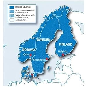 B00XIQKXQE Price: $72.75 Score: 5.917 Category: Electronics Rating: 4 Votes: 82 Find similar productsGarmin City Navigator Nordics for Detailed Maps of Denmark, Finland, Norway, and Sweden (microSD/SD Card). Everything you need to travel the Nordic countries is included in these highly detailed street maps. Load City Navigator Europe NT Nordics directly to your device and navigate turn by turn to any address or intersection. Route to points of interest including restaurants, petrol stations, lodging, attractions and more. Coverage includes detailed maps of Denmark, Finland, Iceland, Norway and Sweden. Powered by NAVTEQ, a world leader in premium-quality digital map data. |  B000O8SIFC Availability: Currently unavailable Score: 5.917 Category: Electronics Rating: 5 Votes: 1 Find similar productsLowrance FreedomMaps USA EX Map - West. Pre-loaded data card featuring greater map detail and topography info for United StatesOver 3000 inland U.S. lakes with depth contourstopographic contour lines elevations overlapping coverage of state borders and exclusive hunting databases. |